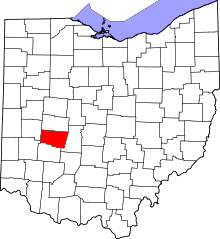
Clark County, Ohio
County in Ohio, United StatesClark County is a county located in the west central portion of the U.S. state of Ohio. As of the 2020 census, the population was 136,001. Its county seat and largest city is Springfield. The county was created on March 1, 1818, and was named for General George Rogers Clark, a hero of the American Revolution. Clark County comprises the Springfield, OH Metropolitan Statistical Area, which is also included in the Dayton-Springfield-Sidney-OH Combined Statistical Area.
Read article
Top Questions
AI generatedMore questions
Nearby Places

Springfield, Ohio
City in the United States

Westcott House (Springfield, Ohio)
Historic house in Ohio, United States
Catholic Central School (Springfield, Ohio)
School in Springfield, , Ohio, United States

Clark County Courthouse (Ohio)
Local government building in the United States

St. Raphael's Catholic Church (Springfield, Ohio)
Historic church in Ohio, United States

St. Joseph's Catholic Church (Springfield, Ohio)
Historic church in Ohio, United States

East High Street Historic District (Springfield, Ohio)
Historic district in Ohio, United States

Carleton Davidson Stadium
Stadium in Springfield, Ohio, US


